28 July 2006
South Lake Tahoe, CA -- Mile 1095

It is a bit of a downer to have left the High Sierra, so spectacular it is. Therefore, I find myself in this lakeside resort town comforting myself with casino all-you-can-eat-buffets. It is some solace, at least. By the way, if anyone is interested, I could give you the name of a wedding chapel in a strip mall, wedged between a Subway and a skateboard shop. South Lake Tahoe is an odd mix of this sort of thing and private jets landing at the airfield nearby.
In the past two weeks I have taken a few side trips. I completed the John Muir Trail, taking me down into Yosemite Valley. While there, I climbed to the top of Half-Dome, saw El Capitan and the climbers on its sheer face and witnessed the more than 1000 foot fall of Yosemite Falls. As I left Yosemite, it really was dramatic how rapidly the geology changed. From wide glacier-carved meadows and polished granite to something more resembling the desert. From something made by ice to rock of volcanic origin. In fact, I will be passing through lava fields in a few weeks.
Eric: It sounds like you are learning Rhode Island-ese wicked good! Actually, a coffee cabinet sounds good right now. Maybe after some quahogs. Right now, there are some confused expressions from those readers not in Rhode Island.
Well, there is a buffet calling my name. Until next time...
16 July 2006
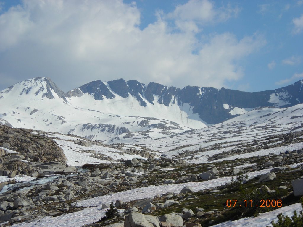
Mammoth Lakes, CA -- Mile 906

I would amend what Beeman said in his recent comment. You should be here. Or, at least we should all experience this kind of beauty somewhere, someplace in our lives. I simply can not do it justice, explaining how gorgeous the trail and its environs have been the past week. I could use every superlative I know, many come to mind, and still feel inadequate to the task. The Pacific Crest Trail through the High Sierra, locally the John Muir Trail, is remarkable. Remarkable. I say this having put quite a bit of trail behind me, that it is without peer the most continually beautiful I have yet hiked.
There has been a fair amount of snow to traverse over the high alpine passes, occasionally with ice axe in hand; the effect of which has been to slow my progress and allow me to savor this amazing landscape. I have repeated the following sequence numerous times over the past hundred or so miles, and I am not done yet: Climb a few thousand feet, the last mile or so on snow to a mountain pass surrounded by even higher snow-capped peaks, glacial tarns and still iced-over lakes. The melt is happening briskly. Water is everywhere. My feet have not been dry, but for brief periods, since Bishop. On the descent the scene is repeated. I continue down a few thousand feet to a broad valley, a basin collecting all the water seen pouring off the mountain. The snowmelt comes together in a lake, which, at its outlet forms a creek and descends further, the trail alongside, deeper into a valley. These rivers, swollen and often furious are crossed by the trail many times. I have been waist-deep or worse on these crossings. The mid-30 degree water would be refreshing in the mid-day heat if it wasn't for the anxiety provoked by these fords. One eye is kept on the feet, making sure I don't misstep, the other on the boiling rapids and falls just downstream. Finally, the low point of the descent is reached and the process is repeated with a new pass, basin, lake, creek...and so it goes.
Unlike other trails through National Parks or Forests, where there tend to be many day-hikers, just about everybody else out here is on a long-distance hike...on the PCT or the 200+ mile John Muir Trail. There just isn't easy access to the trail, you have to work to be here. As a result, there is a tremendous sense of community among hikers, more than seen typically. People look after each other, giving information about upcoming snow conditions, route-finding up the passes, places to camp, fords, bear encounters, etc... There are many conversations about gear, food and other essentials to backpacking. In contrast to being among non-backpackers or weekenders, the question that goes unasked is, "Why are you doing this?" For the community of us long-distance hikers that answer is obvious.
At a resort more like a rustic camp, just off the trail in Vermillion Valley, arrived at by taking a ferry across Lake Edison, I had the pleasure of meeting three people thru-hiking the John Muir Trail and their friend who had come out to meet them for the day. Rocky, Jill, Don and Brian. Brian brought fixings for burritos, I was generously invited to dinner, and we feasted. While much of the time out here is fairly solitary, though pleasantly so, there are times such as this where hikers come together and enjoy each others company, good food and drink. This was such a time. While the desert was not particularly social, the Sierra has been, adding to the Trail experience. So, thank you each of you. I hope your JMT hike finished well.
This week, I move on to Yosemite. And, speaking of generosity, the bus driver who brought me from Red's Meadow to Mammoth volunteered to meet me in town when he got off work, to give me his copy of a John Muir biography of his life in Yosemite Valley. Perfect timing. He was true to his word and I will have the opportunity to read about Muir's life as I enter this storied Valley.
To answer your question Dad, there are few "trail registers" of the sort used on the AT. The ones you come across on the PCT are typically Park or Forest service forms used to keep track of the number of people in the backcountry, with a little room for a comment or two.
Regarding Julie's comment: By know you know I do not swim in the same direction as the rest of the fishes.
Margaret: Yes, I am sure you could take a helicopter tour.
Rob and Maria: Glad to hear from you. Hope you are both well.
07 July 2006
Bishop, CA -- Mile 790
What a difference a week makes...from sweltering desert heat to the cool alpine meadows of the Sierra. From water being scarce to crossing (some thigh-high) swollen-from-snow-melt creeks several times a day. I am thrilled to be here and have been anticipating this as a, maybe THE, highlight of the hike. But first...
I want to thank Beeman, Bob and Glen, fellow PCT hikers, for your comments on the blog, and Beeman for your link to the pictures. It was certainly a pleasure to share a piece of the trail with each of you. And speaking of pictures, since I have not been able to upload pictures to the blog I'll mention this: At the conclusion of my journey I'll burn a CD of pics and mail it to anyone interested. More on this later.
Next order of business...I received an invitation to a retirement party I will regrettably be unable to attend. Friends Shirley and Gordon are retiring from the Army Reserve and Air National Guard, respectively, after a combined 40+ years of outstanding service. An amazing accomplishment. It was an honor to be able to serve with and learn from each of them. And learn much I did, about military life, character and leadership. It is because of selfless citizen-soldiers like Shirley and Gordon that we are blessed with the freedom we enjoy and celebrate, in particular, this week every year. You both have my congratulations and thanks.
As far as the trail goes, I am somewhat at a loss...because I can not possibly describe the natural beauty all around me, all the time, and do it justice. I will try. For the past week I have been living above 10k feet. Most of the time I have been above treeline, with marvelous views, eye-popping views of verdant valleys. Towering peaks still holding onto much snow. Deer, marmots, hawks...a profusion of wildlife I did not see in the desert. To be sure there is much wildlife in the desert, but it tended because of the heat, to be nocturnal and unseen. I have traversed snow fields on my way up to cross high mountain passes. Vast meadows. No roads. Perfect wilderness. I have been swimming in trout-filled lakes. The Sierra is a water world. My sneakers have rarely been completely dry, and unlike the 5 or 6 liters of water carried at a time in the desert, now I need not carry any. Now, when I am thirsty, I walk half-a-mile or less to a creek, and drink clean crisp water I have done a considerable amount of backpacking but have never been on a trail so gorgeous as this. And the best part: I have another 150 miles of High Sierra to go. And Yosemite.
On July 4th I ascended the trail to the summit of Mt. Whitney, the highest peak in the contiguous 48 states. Just short of 15k feet. Not on the PCT, it was a side trip, but one I was not going to pass up. I almost didn't make it.
There was hail earlier in the day and thunderstorms. I hunkered down several miles below the summit, below the safety of the treeline hoping the weather would clear. Mid-afternoon, when the hail and rain stopped I started up. I was not sure even a mile from the summit whether I would make it. There were still threatening clouds on the peak and nearby ridges with occasional lightening strikes. Just as I was weighing whether to turn around, the wind picked up and started clearing out the clouds. I saw my chance. By the time I covered the remaining distance to the top, the front had blown off and I was treated to a fantastic sunset. I made the descent back to my campsite in the dark, only getting there after 10:30, ending what had been an exceedingly long, tiring, rewarding day. 17 hours from the time I woke to the time I crawled exhausted into my bag. More than 31 miles covered, and several thousand feet of elevation gain. My entry in the trail register at the summit: "A very happy Independence Day, indeed!"
Thank you for the birthday wishes.
![]()